MID HOLOCENE WARM PERIOD
Posted on: February 16, 2021
THIS POST IS A SUMMARY AND REVIEW OF THE NOAA STATEMENT ON THE HOLOCENE CLIMATE OPTIMUM AKA MID HOLOCENE WARM PERIOD.
A BIBLIOGRAPHY OF THE HOLOCENE TEMPERATURE CYCLES OVER THE LAST 10,000 YEARS SINCE THE YOUNGER DRYAS IS PRESENTED IN A RELATED POST: LINK: https://tambonthongchai.com/2019/06/11/chaoticholocene/ .
RELATED POST ON THE HOLOCENE CLIMATE OPTIMUM: https://tambonthongchai.com/2018/08/20/the-holocene-optimum-period-a-bibliography/
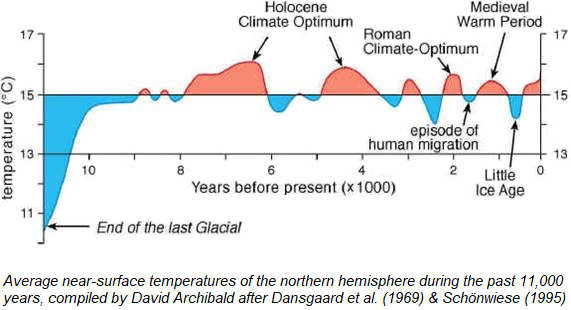
The NOAA study of the Mid-Holocene Warm Period aka Holocene Climate Optimum
Paleoclimatologists have long suspected that the “middle Holocene,” a period roughly from 7,000 to 5,000 years ago, was warmer than the present day. Terms like the Altithermal or Hypsithermal or Climatic Optimum have all been used to refer to this warm period that marked the middle of the current interglacial period. Today, however, we know that these terms are obsolete and that the truth of the Holocene is more complicated than originally believed. What is most remarkable about the mid-Holocene is that we now have a good understanding of both the global patterns of temperature change during that period and what caused them. It appears clear that changes in Earth’s orbit have operated slowly over thousands and millions of years to change the amount of solar radiation reaching each latitudinal band of Earth during each month. The Milankovitch orbital changes predict that the Northern Hemisphere should have been warmer than today during the mid-Holocene in the summer and colder in the winter. The combination of warmer summers and colder winters is apparent for some regions in the proxy records and model simulations. There are some important exceptions to this pattern, however, including colder summers in the monsoon regions of Africa and Asia due to stronger monsoons with associated increased cloud cover during the mid-Holocene, and warmer winters at high latitudes due to reduction of winter sea ice cover caused by more summer melting.
In summary, the mid-Holocene, roughly 6,000 years ago, was generally warmer than today during summer in the Northern Hemisphere. In some locations, this could be true for winter as well. We know that the cause of this natural warming was “astronomical” Milankovitch climate forcing. This forcing doesn’t exist in the warming over the last 100 years. And so the current warming has to be human caused by way of the fossil fuel emissions of the industrial economy. (NOAA).
CONCLUSION: Unlike the usual climate science position that the current warming is unprecedented, NOAA holds the view that perhaps the warming is not unprecedented but the precedented warming in the absence of the causes that explain the precedence, imply human cause if the current warming and because the timing coincides with the industrial economy, that human cause must be the industrial economy.

HOLOCENE CLIMATE OPTIMUM BIBLIOGRAPHY
- 1978: Sarnthein, Michael. “Sand deserts during glacial maximum and climatic optimum.” Nature 272.5648 (1978): 43. The past 20,000 yr have witnessed tremendous climatic changes, a glacial maximum at about 18,000 yr BP and a climatic optimum centred on about 6,000 yr BP, both of which mark extreme situations for the Quaternary. This paper attempts to show that active sand dunes were extensive 18,000 yr ago. Conversely, it seems that sand dunes were generally dormant 6,000 yr ago. Thus the former textbook concept1,2 of an arid climatic optimum and a pluvially active glacial maximum is reversed.
- 1979: Eronen, Matti. “The retreat of pine forest in Finnish Lapland since the Holocene climatic optimum: a general discussion with radiocarbon evidence from subfossil pines.” Fennia-International Journal of Geography 157.2 (1979): 93-114. Literature data on the retreat of the pine forest in Northern Fennoscandia are presented to cover the period from the early 19th century onwards, i.e. since the first reliable observations were made. These data are compared with radiocarbon datings of 44 samples from subfossil pines found at or beyond the present limit of pine forest. The trees had usually been preserved best in moist surroundings, the majority of the trunks and stumps having been recovered from small lakes or wet paludified depressions. Although the dates are scattered over a wide period of time, from about 7000 B.P. up to recent times, there is a concentration around 4000‑6000 B.P. sufficient to suggest that pine forest grew beyond the present limit during the Holocene climatic optimum. The most pronounced retreat in the forest limit since that time is recorded in Enontekiö, in the western part of Finnish Lapland. The results fit well with existing pollen records, which indicate that pine spread to Lapland around 8500‑7500 B.P. and achieved its maximum distribution in the period 7500‑5000 B.P., gradually retreating since then, due to the deteriorating climate.
- 1990: Weidick, Anker, et al. “The recession of the Inland Ice margin during the Holocene climatic optimum in the Jakobshavn Isfjord area of West Greenland.” Palaeogeography, Palaeoclimatology, Palaeoecology 82.3-4 (1990): 389-399. Recent subsurface mapping of parts of the Greenland Inland Ice margin in the region of Jakobshavn Isbræ indicates that the fjord system in the period of at least 2700–4700 calendar yr B.P. was more ice free than at present, and that the front of the glacier was at least 15 km behind the present position. The 14C-datings of subfossils brought to the present ice margin fit with the climatic records from ice cores and confirm the favourable conditions for Greenland’s first settlers, the Sarqaq people, who arrived in the region about 4000 yr ago to find hunting grounds 10–20% larger than the present.
- 1992: Ciais, P., et al. “Evidence for an early Holocene climatic optimum in the Antarctic deep ice-core record.” Climate Dynamics 6.3-4 (1992): 169-177. In the interpretation of the Antarctic deep ice-core data, little attention has been given to the Holocene part of the records. As far as translation of the stable isotope content in terms of temperature is concerned, this can be understood because expected temperature changes may be obscured by isotopic noise of various origins and because no 14C dating has yet been available for this type of sequence. In this article, we focus on the Dome C and Vostok cores and on a new 850-m long ice core drilled out at Komsomolskaïa by the Soviet Antarctic Expeditions. These three sites are located in East Antarctica, on the Antarctic plateau, in a region essentially undisturbed by ice-flow conditions, so that their detailed intercomparison may allow us to identify the climatically significant isotopic signal. Our results compare well with the proximal records of Southern Hemisphere high latitudes and support the existence of a warmer “climatic optimum” between 10 and 6 ka y BP. Maximum temperatures are reached just at the end of the last deglaciation, which confirms previous observations at high latitudes, in contrast with later dates for the Atlantic and hypsithermal optima in Europe and North America.
- 1995: Hjort, Christian, et al. “Radiocarbon dated common mussels Mytilus edulis from eastern Svalbard and the Holocene marine climatic optimum.” Polar Research 14.2 (1995): 239-243. The common mussel Mytilus edulis is an indicator of milder marine conditions in the Arctic, with stronger Atlantic Water influx, during the Holocene and earlier interglacials. Twelve Holocene radiocarbon dates of mytilus from eastern Svalbard fall between ca 8800 and 5000 BP and roughly delimit the marine climatic optimum period there. The beginning of this period in the east coincides with the immigration of boreal extralimital molluscs to western Svalbard, indicating the culmination of Holocene Atlantic influence.
- 1996: Gingele, Franz X. “Holocene climatic optimum in Southwest Africa—evidence from the marine clay mineral record.” Palaeogeography, Palaeoclimatology, Palaeoecology 122.1-4 (1996): 77-87. Sediment composition, grain size and clay mineral record of a high-resolution sediment core from the continental slope off Namibia was investigated to gain information on the deposition of terrigenous matter in this part of the Southwest African continental margin during the last 18 k.y. The depositional processes involved are fluvial input by the Kunene River and eolian input from the Namib and Kalahari deserts, each supplying characteristic mineral suites. During low sea level, erosion of the exposed shelf yields additional material. The amount of eolian or fluvial matter depends on the strength of the transport process, which is a function of aridity or humidity of the source area, thus allowing paleoclimatic interpretations. Arid conditions prevailed during a low sea level from 18 to 15 ka and unconsolidated shelf sediment was mobilized and supplied to the slope by short-distance transport by southerly winds. A dramatic increase in the accumulation of terrigenous sediment is recorded from 15 to 10 ka without major changes in sediment composition, which is attributed to increased runoff of the Kunene River and fluvial erosion of shelf sediments. This period coincides with a strengthening of the monsoonal system during a precessional minimum, which is observed in numerous sites in Central Africa and indicates an intensified influence of the monsoon at the Kunene headwaters. A distinct shift in clay mineralogy towards river-derived material marks a second period of increased river runoff—during high sea level—from 9 to 5 ka, indicating maximum humidity in the source area from 6 to 5 ka. This corresponds to the Holocene climatic optimum observed in the arid belts of Northern Africa. The present balance between fluvial and eolian input was reached approximately at 4 ka.
- 1999: Rossignol-Strick, Martine. “The Holocene climatic optimum and pollen records of sapropel 1 in the eastern Mediterranean, 9000–6000 BP.” Quaternary Science Reviews 18.4-5 (1999): 515-530. The most recent sapropel in the deep eastern Mediterranean Sea has been deposited between 9 and 6 ka bp. Climate conditions, as revealed by the pollen records of this sapropel in marine cores, were most favorable for temperate deciduous trees, which is in agreement with the inferences from records of peripheral land pollen sites. The abundance of deciduous oak pollen is much higher than that of Artemisia (sage-brush), indicating that annual precipitation in the mid-elevation borderlands was at least 550 mm without summer drought, but more probably in the range 800–1300 mm. The pollen of Pistacia, which formed a savanna at low elevations, is also at its highest abundance and signals the absence of frost in winter, while being capable of withstanding summer drought. The early Holocene therefore appears as the post-glacial climatic optimum with the highest moisture and mildest winters. In southwest Asia, this is also the time of the Neolithic population explosion with incipient domestication of cereals, possibly following natural selection of the ‘tough rachis’ mutation in wheat and barley by the extreme aridity of the preceding Younger Dryas.
- 2000: An, Zhisheng, et al. “Asynchronous Holocene optimum of the East Asian monsoon.” Quaternary Science Reviews 19.8 (2000): 743-762. The spatial and temporal distribution of summer monsoon precipitation (or effective moisture) during the Holocene has been reconstructed on the basis of geological data, including lake levels, pollen profiles, and loess/paleosol records. In addition, the summer (July) precipitation increment, effective precipitation, and monsoon strength index have been obtained from numerical modeling experiments. Both geological data and numerical modeling indicate that the Holocene optimum, as defined by peak East Asian summer monsoon precipitation, was asynchronous in central and eastern China, reaching a maximum at different times in different regions, e.g., ca. 10,000–8000 yr ago in northeastern China, 10,000–7000 yr ago in north-central and northern east-central China, ca. 7000–5000 yr ago in the middle and lower reaches of the Yangtze River, and ca. 3000 yr ago in southern China. In southwestern China the maximum appeared ca. 11,000 yr ago, but probably was related to the maximum landward extension of the Indian summer monsoon. The regional shift in the maximum precipitation belt from northwest to southeast over the past 10,000 yr is interpreted as a response to changing seasonality related to orbital forcing of the climate. The southeastward shift of the East Asian summer monsoon maximum is consistent with the progressive weakening of the summer monsoon as the summer solar radiation anomaly decreased progressively through the Holocene and the East Asian monsoon index declined, while the early maximum in southwestern China matches the maximum of the Indian monsoon index.
- 2003: Kalis, Arie J., Josef Merkt, and Jürgen Wunderlich. “Environmental changes during the Holocene climatic optimum in central Europe-human impact and natural causes.” Quaternary Science Reviews 22.1 (2003): 33-79. The priority programme “Changes of the Geo-Biosphere” aimed to reconstruct the environmental history of central Europe with emphasis on the time interval from 9000 to 5500 cal BP (time-slice II), coinciding with the Holocene climatic optimum. During this period, the onset of human activities such as settlement, agriculture and animal husbandry caused environmental changes. Studies of different landscape units in Germany were carried out to identify these anthropogenically induced changes and to distinguish them from natural effects on the environmental system. The investigated archives included laminated lake sediments, fluvial sediments, colluvia and soils, speleothems, peat and coastal sediments. The different archives were examined using refined research methods including a variety of sedimentary and geochemical analyses, together with pollen analysis and dating methods for the establishment of a reliable chronology. The results of the various research groups are summarised and critically discussed. Based on these results, the climatic optimum can be subdivided into three periods: (1) the Early Atlantic from 9000 to 7500 cal BP with negligible human impact and stable environmental conditions; (2) the Late Atlantic during Early and Middle Neolithic from 7500 to 6300 cal BP with pollen evidence for vegetation changes but only negligible changes detectable in other proxy records; and (3) the Late Atlantic during the Younger Neolithic (Jungneolithikum), after 6300 cal BP, with human impact observed in many archives and proxy records especially in the pollen record but also in lacustrine and fluvial sediments. During the whole climatic optimum natural causes, such as minor shifts of temperature, did not induce substantial environmental changes, though some changes, such as temporary droughts, may have facilitated and amplified the observed human impact.
- 2004: Andersen, Christine, Nalan Koc, and M. Moros. “A highly unstable Holocene climate in the subpolar North Atlantic: evidence from diatoms.” Quaternary Science Reviews 23.20 (2004): 2155-2166. A composite record (LO09-14) of three sediment cores from the subpolar North Atlantic (Reykjanes Ridge) was investigated in order to assess surface ocean variability during the last 11 kyr. The core site is today partly under the influence of the Irminger Current (IC), a branch of the North Atlantic Drift continuing northwestward around Iceland. However, it is also proximal to the Sub-Arctic Front (SAF) that may cause extra dynamic hydrographic conditions. We used statistical methods applied to the fossil assemblages of diatoms to reconstruct quantitative sea surface temperatures (SSTs). Our investigations give evidence for different regional signatures of Holocene surface oceanographic changes in the North Atlantic. Core LO09-14 reveal relatively low and highly variable SSTs during the early Holocene, indicating a weak IC and increased advection of subpolar water over the site. A mid-Holocene thermal optimum with a strong IC occurs from 7.5 to 5 kyr and is followed by cooler and more stable late Holocene surface conditions. Several intervals throughout the Holocene are dominated by the diatom species Rhizosolenia borealis, which we suggest indicates proximity to a strongly defined convergence front, most likely the SAF. Several coolings, reflecting southeastward advection of cold and ice-bearing waters, occur at 10.4, 9.8, 8.3, 7.9, 6.4, 4.7, 4.3 and 2.8 kyr. The cooling events recorded in the LO09-14 SSTs correlate well with both other surface records from the area and the NADW reductions observed at ODP Site 980 indicating a surface-deepwater linkage through the Holocene.
- 2004: He, Y., et al. “Asynchronous Holocene climatic change across China.” Quaternary Research 61.1 (2004): 52-63. A review of Holocene climatic variations in different parts of China shows that they were asynchronous. Proxy data from ice cores, pollen, loess, lacustrine sediments, and changes of sea and lake levels demonstrate that many warm and cold oscillations have occurred in China during the Holocene, including a most important climatic event known as the “Holocene optimum,” a milder and wetter period, and that the duration and amplitude of the optimum period, as well as its start and end times, differed in different parts of China. Uplift of the Tibetan plateau over the past millions of years led to the development of the monsoon climate and to complex atmospheric circulation over continental China during the Holocene. As a result, the Holocene optimum began and terminated earlier in high-altitude regions of western China than at lower elevations in eastern China, and the amplitude of the variations was lower in the east. This suggests that the western higher-altitude areas were more sensitive to climatic change than were the eastern lower-altitude areas. Holocene climatic records in the Dunde and Guliya ice cores do not correspond. Inverse δ18O variations between the two cores indicate that the effects of climate and atmospheric processes on the stable isotopes at the two sites differed. The correlation between the isotopic composition of carbonates in lake deposits in western China and climatic variations is similar to that in the ice cores. The climatic resolution in ice cores and lake sediments is higher than that in other media. The lack of precise correspondence of climatic records constructed on the basis of proxy data from different parts of China is a result of the different locations and elevations of the sampling sites, the different resolutions of the source material, and the varied climatic conditions within China. Further work is needed to confirm both the conclusions and the inferences presented here.
- 2004: Zhou, Weijian, et al. “High-resolution evidence from southern China of an early Holocene optimum and a mid-Holocene dry event during the past 18,000 years.” Quaternary Research62.1 (2004): 39-48. Computer models suggest that the Holocene Optimum for East Asian summer monsoon precipitation occurred at different times in different regions of China. Previous studies indicate that this time-transgressive Holocene Optimum should have been experienced about 3000 yr ago in southern China. In this study we describe a section which allows us to test this timing directly. We have closely examined high-resolution eutrophic peat/mud sequences covering the past 18,000 cal yr at Dahu, Jiangxi, on the southern boundary of the mid subtropical zone in China. Late Pleistocene successions in the Dahu record indicate cooler and much wetter conditions relative to synchronous events in north-central China. Our results indicate that the Holocene Optimum occurred between ca. 10,000 and 6000 cal yr ago in southern China, consistent with the global pattern. Conditions were relatively dry and cold from 6000 to 4000 cal yr ago. Our data also support the conclusion that the last deglaciation to early Holocene in the south was much wetter, resulting in the formation of dense broad-leaved forests, which could have acted to moderate land temperature ∼10,000 to 6000 cal yr ago, yielding a stable early-Holocene climate. After 6000 cal yr, forest reduction led to unstable land temperatures, and possibly to a northerly shift of the subtropical high-pressure system. Whatever the mechanism, these changes resulted in decreased precipitation between 6000 and 4000 cal yr B.P. in southern China
- 2004: Yu, Ke-Fu, et al. “High-frequency winter cooling and reef coral mortality during the Holocene climatic optimum.” Earth and Planetary Science Letters 224.1-2 (2004): 143-155. A detailed ecological, micro-structural and skeletal Sr/Ca study of a 3.42 m thick Goniopora reef profile from an emerged Holocene reef terrace at the northern South China Sea reveals at least nine abrupt massive Goniopora stress and mortality events occurred in winter during the 7.0–7.5 thousand calendar years before present (cal. ka BP) (within the Holocene climatic optimum). Whilst calculated Sr/Ca-SST (sea surface temperature) maxima during this period are comparable to those in the 1990s, Sr/Ca-SST minima are significantly lower, probably due to stronger winter monsoons. Such generally cooler winters, superimposed by further exceptional winter cooling on inter-annual to decadal scales, may have caused stress and mortality of the corals about every 50 years. Sea level rose by ∼3.42 m during this period, with present sea-level reached at ∼7.3 ka BP and a sea-level highstand of at least ∼1.8 m occurred at ∼7.0 ka. The results show that it took about 20–25 years for a killed Gonioporacoral reef to recover.
- 2004: Xiao, Jule, et al. “Holocene vegetation variation in the Daihai Lake region of north-central China: a direct indication of the Asian monsoon climatic history.” Quaternary Science Reviews23.14-15 (2004): 1669-1679. DH99a sediment core recovered at the center of Daihai Lake in north-central China was analyzed at 4-cm intervals for pollen assemblage and concentration. The pollen record spanning the last ca 10,000yr revealed a detailed history of vegetation and climate changes over the Daihai Lake region during the Holocene. From ca 10,250 to 7900calyr BP, arid herbs and shrubs dominated the lake basin in company with patches of mixed pine and broadleaved forests, indicating a mild and dry climatic condition. Over this period, the woody plants displayed an increasing trend, which may suggest a gradual increase in warmth and humidity. The period between ca 7900 and 4450calyr BP exhibits large-scale covers of mixed coniferous and broadleaved forests, marking a warm and humid climate. Changes in the composition of the forests indicate that both temperature and precipitation displayed obvious fluctuations during this period, i.e., cool and humid ca 7900–7250calyr BP, warm and slightly humid ca 7250–6050calyr BP, warm and humid between ca 6050 and 5100calyr BP, mild and slightly humid ca 5100–4800calyr BP, and mild and humid ca 4800–4450calyrBP. The period can be viewed as the Holocene optimum (characterized by a warm and moist climate) of north-central China, with the maximum (dominated both by warmest temperatures and by richest precipitations) occurring from ca 6050 to 5100calyr BP. During the period of ca 4450–2900calyr BP, the woody plants declined, and the climate generally became cooler and drier than the preceding period. This period is characterized by a cold, dry episode from ca 4450 to 3950calyr BP, a warm, slightly humid interval between ca 3950 and 3500calyr BP and a mild, slightly dry episode from ca 3500 to 2900calyr BP, and appears to be a transition from warm and humid to cold and dry climatic conditions. Since ca 2900calyr ago, the forests disappeared and the vegetation density decreased, reflecting a cool and dry climate. However, a relative recovery of the woody plants occurring between ca 1700 and 1350calyr BP may denote an increase both in temperature and in precipitation. Fluctuations in the climatic condition of the Daihai Lake region were not only related to changes in the seasonal distribution of solar insolation and in the axis and intensity of the ocean current in the western North Pacific but were also closely linked to variations in the position and strength of polar high-pressure systems and in the pattern and intensity of the Westerly winds.
- 2007: Wang, ShuYun, et al. “The early Holocene optimum inferred from a high-resolution pollen record of Huguangyan Maar Lake in southern China.” Chinese Science Bulletin 52.20 (2007): 2829-2836. A high-resolution pollen record of the past 13000 a from Huguangyan Maar Lake reveals the vegetation and environment changes in southern China during the Holocene. It shows that (i) pollen percentage of trees and shrubs reached 56% during the early Holocene (11600–7800 cal a BP), of which the pollen percentage of tropical trees reached a maximum at 9500-8000 cal a BP, reflecting a hot and wet environment; (ii) during the mid-Holocene (7800–4200 cal a BP), the pollen percentage of montane coniferous trees and herbs increased, while the percentage of tropical-subtropical trees decreased, indicating lower temperature and humidity; (iii) in the late Holocene spanning from 4200 to 350 cal a BP, the pollen percentage of herbs and montane conifer increased significantly, indicating a marked decrease of temperature and humidity. Our pollen data reveal that the time period 9500–8000 cal a BP in southern China represents a climatic optimum for the Holocene characterized by hot and wet conditions. This is consistent with the Holocene optimum found in lower latitude regions globally. We speculate that strong insolation might cause the northward migration of the ITCZ and subtropical summer monsoon front, which resulted in an early Holocene optimum in the Huguangyan area. The dry tendency and climate fluctuations of the middle and late Holocene could be associated with a decrease in solar insolation and frequent ENSO event.
- 2008: Joerin, U. E., et al. “Holocene optimum events inferred from subglacial sediments at Tschierva Glacier, Eastern Swiss Alps.” Quaternary Science Reviews 27.3-4 (2008): 337-350. This study investigates the subglacial sedimentary archive at Tschierva Glacier, Eastern Swiss Alps. Subfossil wood remains found at the retreating glacier tongue indicate that their emergence results from recent transport from an upvalley basin. A confluence-basin-like structure was found to exist by georadar measurements underneath the present glacier. In combination with high resolution age determinations based on dendrochronology and radiocarbon dating it is implied that a retreated Tschierva Glacier allowed vegetation growth and sediment accumulation in that basin. Three periods of glacier recession were detected, which occurred around 9200 cal yr BP, from 7450 to 6650 cal yr BP and from 6200 to 5650 cal yr BP. These periods are called Holocene optimum events (HOE). Accordingly, an equilibrium line rise >220 m compared to the reference period from 1960 to 1985 was inferred from digital elevation models of former glacier extents. Since glacier mass balance depends on summer (June–July–August) temperature and precipitation, an equilibrium line altitude (ELA) rise of 220 m implies a summer temperature increase of about 1.8 °C assuming unchanged precipitation during the dated HOE. Alternative calculations point to probable temperature increase in a broad interval between +1.0 °C taking into account a precipitation change of −250 mm/a to +2.5 °C with +250 mm/a precipitation change, supporting earlier paleotemperature estimates. It is proposed that higher mean summer insolation caused a stronger seasonality during the mid-Holocene as compared to late Holocene conditions.

Leave a comment